Demo Video https://youtu.be/3KliR-3g0_8
cd backend
  go get github.com/gorilla/context
  go get github.com/gorilla/mux
  go run main.go
The server should be running on localhost:8080
cd hostfrontend
  node app.js
The server should be running on localhost:3000
-
frontend
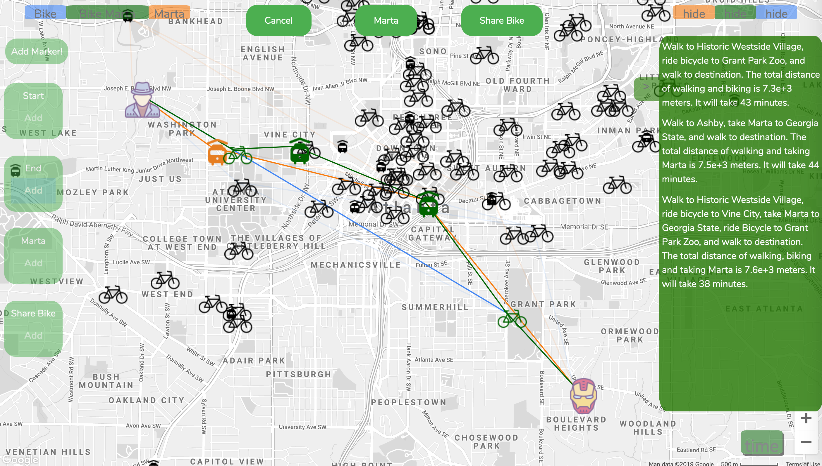
- our integrated google map
-
backend
- api implemented in main.go
- from each endpoint in handleReq() function, the corresponding function can be easily found
/dist/origin/bike: Take User Input k, latitude and longitude. Compute the k closest bike station to the origin /dist/origin/marta: Take User Input k, latitude and longitude. Compute the k closest marta station to the origin /dist/bike/marta: Take User Input k, latitude of bike/marta station and longitude of bike/marta station. Compute the k closest marta station to the bike station. /dist/marta/bike: Take User Input k, latitude of bike/marta station and longitude of bike/marta station. Compute the k closest bike station to the marta station. /dist/walk/bike/marta: calls the above four endpoints for candidate set and enumerate all combinations
- api endpoint for marta: https://opendata.arcgis.com/datasets/7b752dcfca54486c8290b399340a407c_17.geojson
- api endpoint for bike: https://opendata.arcgis.com/datasets/f5b90fe709aa466084dfe2674118e426_27.geojson
-
hostfrontend
- node server to host frontend code
-
test
- check bottom
-
Demo Video https://youtu.be/3KliR-3g0_8
-
Click add marker
-
Add start
- Click a location on our map
-
Add End
- Click a location on our map
-
Suggested route should be generated automatically
-
Change the location of start/end icon by clicking other location. Have fun!
-
Return JSON [{"Stations":["Tech Parkway","Atlantic Station"],"Coords":[[33.8031772871,-84.50643562260001],[33.777526808601124,-84.40759279905951],[33.79327387831942,-84.39788820975087],[33.8237153622,-84.43450950559998]],"TotalCal":1084.770867971532,"TotalTime":8469.259736183943},{"Stations":["Tech Parkway","14th \u0026 Howell Mill Rd"],"Coords":[[33.8031772871,-84.50643562260001],[33.777526808601124,-84.40759279905951],[33.78588862492411,-84.41137697891648],[33.8237153622,-84.43450950559998]],"TotalCal":1041.0060754589008,"TotalTime":8213.113795418363},{"Stations":["14th \u0026 Howell Mill Rd","Atlantic Station"],"Coords":[[33.8031772871,-84.50643562260001],[33.78588862492411,-84.41137697891648],[33.79327387831942,-84.39788820975087],[33.8237153622,-84.43450950559998]],"TotalCal":1025.3175921869733,"TotalTime":8040.157135702016},{"Stations":["14th \u0026 Howell Mill Rd","14th \u0026 Howell Mill Rd"],"Coords":[[33.8031772871,-84.50643562260001],[33.78588862492411,-84.41137697891648],[33.78588862492411,-84.41137697891648],[33.8237153622,-84.43450950559998]],"TotalCal":960.7779208996385,"TotalTime":7667.820597762477}]
| Method | Path | Description |
|---|---|---|
| get | /dist/origin/marta | parameter: k (stations), lat, lng return [{"Name":"Inman Park-Reynoldstown","Dist":1282.4069476253053,"Coord":[33.757410764920266,-84.35275687836776]},{"Name":"King Memorial","Dist":1585.314178280163,"Coord":[33.7498080710845,-84.37554588614684]}] |
| get | /dist/origin/bike | parameter: k (stations), lat, lng return [{"Name":"Highland Ave - Freedom Trail Park","Dist":0,"Coord":[33.76147456195493,-84.36572268184585]},{"Name":"Eastside BeltLine \u0026 Irwin","Dist":432.05950572295995,"Coord":[33.75769038253729,-84.36468508386245]}] |
| get | /dist/bike/marta | parameter: k (stations), lat, lng return [{"Name":"Inman Park-Reynoldstown","Dist":1282.4069476253053,"Coord":[33.757410764920266,-84.35275687836776]},{"Name":"King Memorial","Dist":1585.314178280163,"Coord":[33.7498080710845,-84.37554588614684]}]] |
| get | /dist/marta/bike | parameter: k (stations), lat, lng return [{"Name":"Highland Ave - Freedom Trail Park","Dist":0,"Coord":[33.76147456195493,-84.36572268184585]},{"Name":"Eastside BeltLine \u0026 Irwin","Dist":432.05950572295995,"Coord":[33.75769038253729,-84.36468508386245]}] |
| get | /dist/walk/bike/walk /dist/walk/marta/walk /dist/walk/bike/marta | parameter: k (stations), lat1, lng1, lat2, lng2 return [{"Stations":["14th \u0026 Howell Mill Rd","14th \u0026 Howell Mill Rd"],"Coords":[[33.8031772871,-84.50643562260001],[33.78588862492411,-84.41137697891648],[33.78588862492411,-84.41137697891648],[33.8237153622,-84.43450950559998]],"TotalDist":13725.398869994833,"TotalTime":7667.820597762477}] |
| get | /cal/walk/bike/walk /cal/walk/bike/marta /cal/walk/marta/walk | parameter: k (stations), lat1, lng1, lat2, lng2 return [{"Stations":["14th \u0026 Howell Mill Rd","14th \u0026 Howell Mill Rd"],"Coords":[[33.8031772871,-84.50643562260001],[33.78588862492411,-84.41137697891648],[33.78588862492411,-84.41137697891648],[33.8237153622,-84.43450950559998]],"TotalCal":960.7779208996385,"TotalTime":7667.820597762477}] |
- Generate random coordiantes by
python3 generateRandom.py [number of points]
-
We have 2 test files, one is inputlist.txt, which tests random generated origin points and destinaion points around Atlanta city. The other is intputlistMarta.txt which is another test file with randomed origin points and ends at randomed selected Marta stations.
-
How to run the test: run the following command and you should be able to see the output.txt after a while. You should be able to see the best route from each test cases and the total runtime at the end.
-
You may change the input test file through changing the 13 line of the testK.py.
python3 testK.py K_VALUE